


WASHINGTON Voting District, Carroll County, Illinois
About
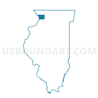
Outline

Summary
| Unique Area Identifier | 564683 |
| Name | WASHINGTON Voting District |
| County | Carroll County |
| State | Illinois |
| Area (square miles) | 39.74 |
| Land Area (square miles) | 35.39 |
| Water Area (square miles) | 4.35 |
| % of Land Area | 89.06 |
| % of Water Area | 10.94 |
| Latitude of the Internal Point | 42.15678490 |
| Longtitude of the Internal Point | -90.16047840 |
Maps


Graphs
Select a template below for downloading or customizing gragh for WASHINGTON Voting District, Carroll County, Illinois


Neighbors
Neighoring Voting District (by Name) Neighboring Voting District on the Map
- DERINDA Voting District, Jo Daviess County, IL
- HANOVER Voting District, Jo Daviess County, IL
- IOWA TWP W/O MILES Voting District, Jackson County, IA
- MT CARROLL 2 Voting District, Carroll County, IL
- PLEASANT VALLEY Voting District, Jo Daviess County, IL
- SAVANNA 1 Voting District, Carroll County, IL
- SAVANNA 4 Voting District, Carroll County, IL
- UNION TWP Voting District, Jackson County, IA
- WASHINGTON TWP Voting District, Jackson County, IA
- WOODLAND Voting District, Carroll County, IL
Top 10 Neighboring County Subdivision (by Population) Neighboring County Subdivision on the Map
- Savanna township, Carroll County, IL (3,729)
- Mount Carroll township, Carroll County, IL (2,279)
- Hanover township, Jo Daviess County, IL (1,201)
- Iowa township, Jackson County, IA (772)
- Union township, Jackson County, IA (762)
- Washington township, Carroll County, IL (356)
- Washington township, Jackson County, IA (348)
- Derinda township, Jo Daviess County, IL (321)
- Woodland township, Carroll County, IL (280)
- Pleasant Valley township, Jo Daviess County, IL (273)
Top 10 Neighboring Place (by Population) Neighboring Place on the Map
Top 10 Neighboring Unified School District (by Population) Neighboring Unified School District on the Map
- West Carroll Community Unit School District 314, IL (8,701)
- Bellevue Community School District, IA (4,425)
- Stockton Community Unit School District 206, IL (3,901)
- River Ridge Community Unit School District 210, IL (3,724)
- East Central Community School District, IA (2,263)
Top 10 Neighboring State Legislative District Lower Chamber (by Population) Neighboring State Legislative District Lower Chamber on the Map
- State House District 89, IL (106,266)
- State House District 71, IL (104,867)
- State House District 25, IA (29,236)
Top 10 Neighboring State Legislative District Upper Chamber (by Population) Neighboring State Legislative District Upper Chamber on the Map
- State Senate District 45, IL (209,870)
- State Senate District 36, IL (206,729)
- State Senate District 13, IA (57,521)
Top 10 Neighboring 111th Congressional District (by Population) Neighboring 111th Congressional District on the Map
Top 10 Neighboring Census Tract (by Population) Neighboring Census Tract on the Map
- Census Tract 9504, Jackson County, IA (3,610)
- Census Tract 9503, Jackson County, IA (3,533)
- Census Tract 205, Jo Daviess County, IL (3,244)
- Census Tract 9603, Carroll County, IL (3,176)
- Census Tract 204.02, Jo Daviess County, IL (3,102)
- Census Tract 9602, Carroll County, IL (2,165)
Top 10 Neighboring 5-Digit ZIP Code Tabulation Area (by Population) Neighboring 5-Digit ZIP Code Tabulation Area on the Map
- 52031, IA (5,120)
- 61074, IL (4,431)
- 61028, IL (1,989)
- 61041, IL (1,327)
- 52070, IA (1,128)
- 52064, IA (847)